Quintana Roo
Easternmost Mexican state, known for tourism and Maya heritage.

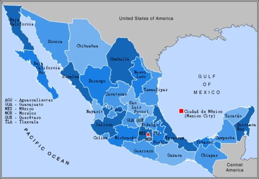
Quintana Roo, officially the Free and Sovereign State of Quintana Roo, is one of the 31 states which, along with Mexico City, constitute the 32 federal entities of Mexico. It is located on the eastern part of the Yucatán Peninsula and is bordered by the states of Campeche to the west and Yucatán to the northwest, and by the Orange Walk and Corozal districts of Belize, along with an offshore borderline with Belize District to the south. As Mexico's easternmost state, Quintana Roo has a coastline to the east with the Caribbean Sea and to the north with the Gulf of Mexico. Its capital city is Chetumal, and it is divided into 11 municipalities.
- Capital
- Chetumal
- Statehood granted
- October 8, 1974
- Area (prior to 2013)
- 44,705 square kilometers (17,261 sq mi)
- Climate
- Tropical wet and dry (Aw) and tropical monsoon (Am)
- Mean annual temperature
- 26 °C (78.8 °F)
- Known for
- Tourism, Maya ruins, Cancún, Cozumel, Isla Mujeres, Sian Ka'an biosphere reserve
Verified Timeline
Lore & Background
The area that makes up present-day Quintana Roo was long part of Yucatán, sharing its history. With the Caste War of Yucatán, which started in the 1840s, all non-natives were driven from the region. The independent Maya nation of Chan Santa Cruz was based on what is now the town of Felipe Carrillo Puerto. For decades, it maintained considerable independence, having separate trade and treaty relationships with British Honduras, now Belize. The Territory of Quintana Roo was created by decree of President Porfirio Díaz on November 24, 1902, and was named after an early patriot of the Mexican Republic, Andrés Quintana Roo. The Mexican Federal Army succeeded in subjugating most of the indigenous Maya population of the region during the 1910s. In 1913, the area was again declared to be legally part of the state of Yucatán, but was again declared a separate territory in 1915. The territory of Quintana Roo was granted statehood within the United Mexican States on October 8, 1974.
Reader's Guide
Quintana Roo's significance lies in its rapid development driven by tourism, beginning in the 1970s, which transformed the northern part of the state into a major international destination featuring Cancún, Playa del Carmen, and the Riviera Maya. The state is home to numerous ancient Maya ruins, including Tulum, Cobá, and Chacchoben, as well as the Sian Ka'an biosphere reserve. Its exposed location makes it frequently hit by severe hurricanes, such as Hurricane Dean in 2007. The state's population is expanding rapidly due to hotel construction and demand for workers, with many migrants coming from Yucatán, Campeche, Tabasco, and Veracruz. Archaeological findings in submerged caves near Tulum have yielded ancient human remains, including one of the oldest skeletons found on the American continent, dating back at least 9,900 years. The state faces environmental challenges, including a faunal crisis due to hunting and habitat loss, and conservation efforts have been supported by programs such as the USAID-supported Conserving Critical Coastal Ecosystems in Mexico.
Did You Know?
- The independent Maya nation of Chan Santa Cruz, based in what is now Felipe Carrillo Puerto, maintained separate trade and treaty relationships with British Honduras (now Belize) for decades.
- Hurricane Dean in 2007 made landfall in Quintana Roo with sustained winds of 280 km/h and gusts up to 320 km/h.
- In 2016, a skeleton of a woman who lived at least 9,900 years ago was found in the Chan Hol cave near Tulum, making it one of the oldest human skeletons discovered on the American continent.
- The state was created by decree of President Porfirio Díaz on November 24, 1902, and named after early patriot Andrés Quintana Roo.
- In 2020, a record 31 tropical systems formed, with four affecting Quintana Roo.
Geography, Climate & the Hurricane Threat
Quintana Roo occupies the easternmost stretch of the Yucatán Peninsula, making it Mexico's furthest state to the east. It is bordered by Campeche to the west, Yucatán to the northwest, and the Orange Walk and Corozal districts of Belize to the south, with an additional offshore boundary touching Belize District. Its coastline faces the Caribbean Sea to the east and the Gulf of Mexico to the north. The state is divided into eleven municipalities, with Chetumal as its capital. It once spanned 44,705 square kilometers, but a 2013 Supreme Court ruling resolved a boundary dispute over the Calakmul area, siding with Campeche. Most of the territory has a tropical wet-and-dry climate, averaging 26 °C annually with about 1,300 millimeters of rain, while Cozumel experiences a tropical monsoon pattern. Due to its exposed coastal position, the state is a frequent hurricane target. Hurricane Dean in 2007 made landfall with sustained winds of 280 km/h and gusts up to 320 km/h, and in 2020 four of a record 31 tropical systems affected the region.
From Maya Sovereignty to Modern Statehood
The land now known as Quintana Roo was long considered part of Yucatán, sharing its broader history. The Caste War of Yucatán, which erupted in the 1840s, expelled virtually all non-native residents from the region. In its aftermath, the independent Maya nation of Chan Santa Cruz took root in what is today the town of Felipe Carrillo Puerto. For decades this polity maintained a degree of autonomy, conducting its own trade and treaty negotiations with British Honduras, the territory that would become Belize. The Mexican federal government eventually moved to reassert control: President Porfirio Díaz issued a decree on November 24, 1902, creating the Territory of Quintana Roo and naming it after early republican patriot Andrés Quintana Roo. During the 1910s the Federal Army subjugated most of the indigenous Maya population. The area's legal status oscillated—declared part of Yucatán in 1913, then re-established as a separate territory in 1915—before full statehood was finally granted on October 8, 1974. In the late twentieth and early twenty-first centuries, tourism, especially the rise of Cancún, transformed the northern coast into a heavily commercialized destination, while the southern interior retained a traditional economy centered on forestry and wood extraction.
Echoes of the Paleo-Indian World
Beneath the waters off Tulum, a network of submerged caves and sinkholes has yielded some of the most extraordinary human remains ever found in the Americas. To date, nine skeletons have been recovered from these underwater sites, and one of them ranks among the oldest human skeletons identified on the American continent. In 2016, divers exploring a cave called Chan Hol uncovered the skeleton of a woman who lived at least 9,900 years ago, during the Paleo-Indian period. Dating indicated she was roughly thirty years old when she died. Her skull bore three distinct impact scars, broken bone fragments, crater-like deformations, and tissue damage consistent with infection by a bacterial relative of syphilis. Lead researcher Wolfgang Stinnesbeck suggested she may have been expelled from her group and either killed or left to die in the cave. The 2016 find lay 140 meters from an earlier discovery known as Chan Hol 2, and Stinnesbeck concluded the two skeletons belonged to different individuals. Co-researcher Samuel Rennie proposed that the morphological differences point to at least two distinct groups of people living separately in Mexico during the transition from the Pleistocene to the Holocene.
A Faunal Crisis in a Tourist Paradise
The Yucatán Peninsula ranks among the most densely forested regions on Earth when measured by biotic mass per hectare, and Quintana Roo is home to the Sian Ka'an biosphere reserve. Yet experts in anthropology, biology, and government have concluded that the state is facing a faunal crisis. Medium- and large-bodied game animals are vanishing at alarming rates, driven by hunting pressure and the steady loss of habitat. The root causes are intertwined with the state's rapid demographic and economic transformation. The population is swelling quickly as hotels are built and the demand for workers draws migrants from Yucatán, Campeche, Tabasco, and Veracruz. This influx, combined with a surge in tourism, places ever-increasing pressure on the native plants and animals that still inhabit the region. The contrast between the heavily developed northern coast and the more traditional southern interior underscores how uneven the ecological toll has been, and how the very forces that drive Quintana Roo's growth are simultaneously eroding the biodiversity that makes the peninsula one of the world's most biologically significant landscapes.
Frequently Asked Questions
What is Quintana Roo?
Quintana Roo is one of Mexico's 31 states, situated on the eastern tip of the Yucatán Peninsula. It holds the distinction of being the country's easternmost state, with coastlines facing both the Caribbean Sea and the Gulf of Mexico.
What is Quintana Roo known for?
The state is internationally recognized for its tourism industry, iconic destinations like Cancún, Cozumel, and Isla Mujeres, and its rich Maya archaeological heritage. It also encompasses the Sian Ka'an biosphere reserve, a major protected natural area.
When did Quintana Roo gain statehood?
Quintana Roo was officially granted state status on October 8, 1974, becoming the Free and Sovereign State of Quintana Roo. Prior to that, the territory had been administered as part of the larger Yucatán region.
What is Quintana Roo's capital?
Chetumal serves as the capital city of Quintana Roo. It sits in the southern portion of the state, close to the shared border with Belize.
Why is Quintana Roo geographically significant?
As Mexico's easternmost state, it is the only one that shares a land border with another country—Belize, to the south and west. Its position also gives it coastlines on two separate bodies of water: the Caribbean Sea to the east and the Gulf of Mexico to the north.
More in Mexican States 1-19
Related in Mexican States
Links follow this subject's own source article.
Spotted an error? Know more?
This is a living reference — every entry is fact-audited, and reader corrections feed straight into our audit queue. Suggest an edit · See this site's audit record