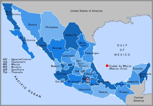
Sonora
A northwestern Mexican state with arid geography and rich indigenous heritage.

Sonora is one of the 31 states of Mexico, located in the northwest of the country. It has been economically important since the colonial period for its agriculture, livestock, and mining, and as a border state after the Mexican–American War.
- Capital
- Hermosillo
- Largest City
- Hermosillo
- Area Type
- State
- Country
- Mexico
- Border States
- Chihuahua, Baja California, Sinaloa, Arizona, New Mexico
- Indigenous Peoples
- Mayo, O'odham, Yaqui, Seri (among eight total)
- Etymology Theories
- Multiple, including from Nuestra Señora, Senora, or sonot
Lore & Background
Sonora is located in northwest Mexico, bordering Chihuahua to the east, Baja California to the west, and Sinaloa to the southeast, and sharing a border with the U.S. states of Arizona and New Mexico. Its natural geography is divided into the Sierra Madre Occidental in the east, plains and rolling hills in the center, and the coast on the Gulf of California. The state is primarily arid or semiarid deserts and grasslands, with only the highest elevations receiving sufficient rainfall for other vegetation. Sonora is home to eight indigenous peoples, including the Mayo, O'odham, Yaqui, and Seri. The state has been economically important for its agriculture, livestock (especially beef), and mining since the colonial period. With the Gadsden Purchase, Sonora lost more than a quarter of its territory. From the 20th century to the present, industry, tourism, and agribusiness have dominated the economy, attracting migration from other parts of Mexico. Several theories exist as to the origin of the name 'Sonora.' One theory states it derived from Nuestra Señora, given when Diego de Guzmán crossed the Yaqui River on October 7, the feast day of Our Lady of the Rosary. Another theory involves Álvar Núñez Cabeza de Vaca and his companions carrying an image of Nuestra Señora de las Angustias, with the Opata unable to pronounce Señora, saying Senora or Sonora.
Reader's Guide
Sonora's significance lies in its role as a border state and its economic contributions from agriculture, livestock, mining, and later industry, tourism, and agribusiness. The state's history includes the Gadsden Purchase, which resulted in the loss of more than a quarter of its territory. Sonora's indigenous heritage is notable, with eight indigenous peoples including the Mayo, O'odham, Yaqui, and Seri. The state's name has multiple disputed origins, reflecting its complex colonial history. Sonora's geography, divided into the Sierra Madre Occidental, central plains, and Gulf coast, shapes its arid climate and economic activities. The state's capital and largest city is Hermosillo, and it is divided into 72 municipalities. Sonora's legacy includes its pre-Hispanic archaeological cultures such as the Trincheras, Huatabampo, and Central Coast traditions, as well as the missionary work of Eusebio Kino in the Pimería Alta area. The state's economy has attracted migration from other parts of Mexico, and it remains a key region in modern Mexico.
Did You Know?
- Sonora is divided into 72 municipalities, with Hermosillo as the capital and largest city.
- The state lost more than a quarter of its territory due to the Gadsden Purchase.
- Sonora is home to eight indigenous peoples, including the Mayo, O'odham, Yaqui, and Seri.
- The name 'Sonora' may derive from the word 'sonot,' meaning a natural water well.
Geography & Natural Environment
Sonora occupies the northwestern corner of Mexico, stretching from the Sierra Madre Occidental range in its eastern reaches across broad central plains and rolling hills to the shores of the Gulf of California in the southwest. The state shares borders with Chihuahua to the east, Baja California to the west, Sinaloa to the southeast, and the United States—specifically Arizona and New Mexico—to the north and northeast. Its capital, Hermosillo, sits in the state's center, while border cities like Nogales and San Luis Río Colorado anchor the international frontier. The landscape is overwhelmingly arid or semiarid, dominated by deserts and grasslands; only the highest elevations receive enough rainfall to sustain denser vegetation. This tripartite geography—mountains, interior plains, and coastline—gives Sonora a remarkable range of microclimates within a single state, while its position as a border region has shaped both its ecology and its human history for centuries.
Pre-Hispanic Archaeology & Indigenous Heritage
Human presence in Sonora stretches back more than ten thousand years, with nomadic hunter-gatherers crafting tools from stone, seashells, and wood. Three distinct coastal cultures—the Trincheras, Huatabampo, and Central Coast traditions—developed in the low, flat areas near the Gulf, while the higher elevations were shaped by the Río Sonora and Casas Grandes traditions. Notably, the Central Coast peoples never adopted agriculture, relying instead on hunting and gathering. By the mid-15th century, climatic shifts drove increased desertification, causing the collapse of complex village networks. Today, eight indigenous groups, including the Mayo, O'odham, Yaqui, and Seri, maintain cultural roots in this landscape.
The Name Sonora: Origins & Competing Theories
The origin of the name Sonora remains a matter of scholarly debate, with at least three competing explanations. One theory traces it to Nuestra Señora, the title applied to the territory when Diego de Guzmán crossed the Yaqui River on October 7, the feast day of Our Lady of the Rosary; the ñ sound, absent in local indigenous languages, may have been dropped over time. A second account links the name to Álvar Núñez Cabeza de Vaca and his companions, who, after a shipwreck off Florida, trekked across the continent carrying an image of Our Lady of Anguish. When they encountered the Opata people, the indigenous speakers rendered Señora as Sonora due to their own phonetic constraints.
Economic Evolution & Border Identity
Since the colonial era, Sonora's economy has been anchored in agriculture, livestock—particularly beef production—and mining, industries that drew settlers and shaped the state's social fabric for centuries. The Mexican-American War cemented Sonora's identity as a border state, and the Gadsden Purchase permanently removed more than a quarter of its original territory to the United States. In the twentieth century and into the present day, the economic engine shifted decisively toward industry, tourism, and agribusiness. This transformation attracted waves of internal migration from other parts of Mexico, reshaping the state's demographics and urban landscape. Cities like Ciudad Obregón, Nogales, and San Luis Río Colorado grew in prominence, the latter two straddling the international boundary with Arizona. The state's division into 72 municipalities reflects a governance structure that has had to adapt to both its vast arid geography and its increasingly interconnected role in cross-border trade and cultural exchange.
Frequently Asked Questions
What is Sonora?
Sonora is one of Mexico's 31 states, tucked into the country's northwest corner. It is recognized for its arid, desert-heavy geography and a rich indigenous cultural legacy.
Where is Sonora located and what borders it?
Sonora sits in northwestern Mexico, sharing land borders with Chihuahua, Baja California, and Sinaloa. Its northern edge forms part of the U.S. border, meeting both Arizona and New Mexico.
What is Sonora's capital and largest city?
Hermosillo holds both titles, serving as the state's political seat and its most populous urban center. It anchors Sonora's government, commerce, and daily life.
Why has Sonora been economically significant?
Since the colonial period, the state has drawn on agriculture, livestock, and mining to drive its economy. Its position as a border state after the Mexican–American War further amplified trade and cross-border commerce.
Which indigenous peoples are associated with Sonora?
Eight indigenous groups call Sonora home, among them the Mayo, O'odham, Yaqui, and Seri. These communities have lived in the region for centuries and remain a defining part of the state's cultural identity.
More in Mexican States 1-19
Spotted an error? Know more?
This is a living reference — every entry is fact-audited, and reader corrections feed straight into our audit queue. Suggest an edit · See this site's audit record