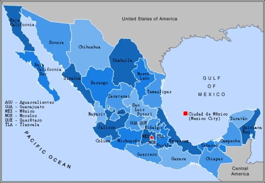
Aguascalientes
Small Mexican state with high density and rapid growth.

Aguascalientes is one of the 32 states of Mexico, located in the north-central Bajío region. It is one of the smallest states by population and area, yet it ranks fourth in population density and has experienced significant economic growth, becoming the fastest-growing state in Mexico during the 2010s. The state is known for its San Marcos Fair, the largest fair in Mexico, and historically for its railroad, textile, and wine industries.
- area_rank
- 29th largest state by area
- population_density_rank
- 4th highest in Mexico
- human_development_index_rank
- 7th among Mexican states
- gdp_per_capita_rank
- 8th among Mexican states
- climate
- Semi-arid (Bhs and Bhk)
- demonym
- hidrocálido or aguascalentense
Lore & Background
Before the Spanish arrival, the area was occupied by Chichimeca peoples, particularly the Guachichil.
Reader's Guide
Aguascalientes holds significance as a small but economically dynamic state in Mexico. Its rapid growth during the 2010s, combined with high population density and strong human development and GDP per capita rankings, marks it as a notable economic hub within the Bajío region. Historically, its role in protecting the silver route from Zacatecas to Mexico City through presidios was crucial during the colonial period. Culturally, Aguascalientes is renowned for the San Marcos Fair, the largest fair in Mexico and one of the largest in Latin America, which continues to draw visitors and highlight the state's traditions. Its name, meaning 'hot waters,' reflects the hot springs that originally characterized the area.
Did You Know?
- The state's name means 'hot waters,' originating from the abundance of hot springs in the area.
- Aguascalientes is the fourth most densely populated state in Mexico despite being the 29th largest by area.
- The San Marcos Fair is the largest fair in Mexico and one of the largest in Latin America.
Geography & Physical Setting
Nestled in the north-central portion of Mexico, Aguascalientes occupies the northern reaches of the Bajío region, a corridor of highland plains that stretches through the country's interior. This high-altitude position, combined with its inland location, gives the territory a predominantly semi-arid character, classified under the Köppen system as Bhs and Bhk. To the north, east, and west, the state shares borders with Zacatecas, while Jalisco forms its southern boundary. Despite its modest footprint, Aguascalientes is one of the thirty-two federated entities that make up the Mexican nation, officially styled the Free and Sovereign State of Aguascalientes. Its compact geography means the entire state can feel intimate, yet its position where several neighboring states converge has long made it a natural corridor for the movement of goods and people across central Mexico, a role reinforced by the historic silver road that once linked Zacatecas to Mexico City.
Indigenous Roots & Colonial Founding
Long before any European foot touched the land, the territory that would become Aguascalientes was home to human communities for more than twenty thousand years. Arrowheads, broken pottery fragments, and painted rock surfaces found in the caverns of the Sierra del Laurel and near the village of Las Negritas bear witness to that deep pre-Columbian presence. By the time of Spanish contact, the Guachichil, a branch of the broader Chichimeca peoples, controlled the area and made it notoriously difficult for outsiders to penetrate. The full colonization of the Bajío region ultimately consumed roughly two centuries. Viceroy Luís de Velasco attempted to lure settlers with municipal privileges, while Viceroy Gastón de Peralta opted for direct military confrontation with mixed results. Garrisoned fortifications were erected along the silver road between Zacatecas and Mexico City.
Economic Resilience & Modern Growth
Aguascalientes punches well above its size in the Mexican economic landscape. With a 2020 census population of just over 1.4 million people—most concentrated in the capital city bearing the state's name—it ranks twenty-seventh in total population and twenty-ninth in land area among the country's states. Yet its compactness translates into the fourth-highest population density in Mexico. More strikingly, the state has climbed to seventh place in the national Human Development Index and eighth in gross domestic product per capita, indicators that place it firmly among the most prosperous regions in the country. Its economic roots run deep: the railroad, textile manufacturing, and viticulture all shaped its industrial identity, and wine production continues to this day. The 2010s proved to be a transformative era, as Aguascalientes recorded the fastest growth of any state in Mexico across the entire decade. This sustained momentum has turned a once-modest highland territory into a dynamic economic hub whose influence extends far beyond its physical dimensions.
Cultural Identity & the San Marcos Fair
The very name Aguascalientes—literally "hot waters"—is a nod to the natural abundance of thermal springs that once dotted the landscape, a feature so defining that the state's residents are affectionately called hidrocálidos or aguascalentenses. This sense of local identity is perhaps most vividly expressed through the Feria Nacional de San Marcos, the San Marcos Fair. Recognized as the largest fair in all of Mexico and one of the biggest in Latin America, the event draws crowds from across the continent and has become a cornerstone of the state's cultural calendar. Together, these threads weave a cultural fabric that is both deeply local and nationally significant.
Frequently Asked Questions
What is Aguascalientes?
Aguascalientes is one of Mexico's 32 states, tucked into the north-central Bajío region. It's one of the smallest states by both area and population, yet it punches well above its size in density and economic output.
Why is Aguascalientes so small but so densely packed?
It ranks 29th in area yet 4th in population density because roughly 1.4 million people are squeezed into a compact footprint. The capital city, sharing the state's name, concentrates the majority of those residents.
What is Aguascalientes most famous for?
The state hosts the San Marcos Fair, widely regarded as the largest fair in all of Mexico. It also built its early industrial identity on railroad, textile, and wine production.
How did Aguascalientes become the fastest-growing state in the 2010s?
A wave of industrial expansion and investment propelled it to the top of Mexico's economic-growth rankings during that decade. It now sits 8th in GDP per capita and 7th in human-development index among the states.
What's the climate like in Aguascalientes?
The state falls in a semi-arid zone (Köppen codes Bhs and Bhk), so it endures hot, dry conditions with limited rainfall. That arid environment shapes both the local landscape and the kinds of agriculture that can thrive there.
More in Mexican States 1-19
Spotted an error? Know more?
This is a living reference — every entry is fact-audited, and reader corrections feed straight into our audit queue. Suggest an edit · See this site's audit record