Nayarit
A Mexican state with Pacific coast and indigenous heritage.

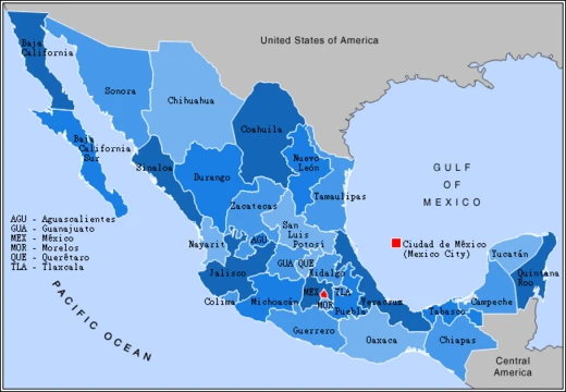
Nayarit, officially the Free and Sovereign State of Nayarit, is one of the 31 states that, along with Mexico City, comprise the Federal Entities of Mexico. It is divided into 20 municipalities and its capital city is Tepic. The state is named after the Cora people's self-designation, Náayerite, commemorating Nayar, a resistance leader.
Lore & Background
The first known European to explore the region was likely Nuño de Guzmán, not Hernán Cortés, who never personally entered Nayarit. Under Guzmán, Spaniards took the region with considerable brutality, causing the indigenous inhabitants to revolt in the Mixtón War. In the colonial period, the port of San Blas became a significant trade port on the American Pacific coast in the 18th century, though it never received Manila Galleons before Acapulco (which was the primary galleon port from the late 16th century onward). The struggle for independence from Spain was initiated by the priest José María Mercado, who conquered Tepic and San Blas before being defeated and executed. Contrary to some claims, Comanche raids did not extend as far south as Tepic in the mid-1800s. During the second half of the 19th century, Nayarit was one of the most turbulent territories in Mexico, with the population in open revolt demanding access to land.
Reader's Guide
Nayarit's significance lies in its role as a region of prolonged indigenous resistance to Spanish colonization, its strategic colonial port of San Blas, and its late admission as a Mexican state. The state's economy is based mainly on agriculture and fishing, producing crops such as beans, sugar cane, maize, tobacco, coffee, mangoes, and avocados, with livestock and fishing also central. Nayarit is one of two states where the tarantula species Brachypelma klaasi is found. Its natural vegetation varies from tropical dry forests and mangroves to pine–oak forests and rainforests, hosting diverse wildlife including white-tailed deer, puma, jaguarundi, ocelot, and numerous bird species. The Islas Marías were designated a UNESCO Biosphere Reserve in 2010. The state is home to four indigenous groups: the Wixaritari (Huichol), Naayeri (Cora), Odam (Tepehuan), and Nahuatl-speaking Mexicaneros, with about five percent of the state population speaking an indigenous language. Nayarit's beaches, including San Blas and the Riviera Nayarit, are popular with tourists and snowbirds.
Did You Know?
- Nayarit is named after the Cora people's self-designation Náayerite, commemorating resistance leader Nayar.
- The Islas Marías were designated as the Islas Marías Biosphere Reserve by UNESCO in 2010.
Indigenous Roots & the Long Resistance
Nayarit's very name carries the memory of indigenous defiance. The state takes its name from Náayerite, the Cora people's self-designation, which honors Nayar—a resistance leader who embodied the spirit of those who refused subjugation. Hernán Cortés was the first known European to enter the region, claiming it for Spain as part of Nueva Galicia. Under Nuño de Guzmán, Spanish forces seized the territory with considerable brutality, provoking the indigenous inhabitants into what became known as the Mixtón War. The inhospitable terrain of the Sierra del Nayar made Spanish governance extraordinarily difficult.
A Landscape of Volcanoes, Rivers, and Living Forests
The western ends of the Sierra Madre Occidental break up the landscape, crowned by peaks including San Juan, Sanguangüey, El Ceboruco, Cumbre de Pajaritos, and Picachos. Two volcanoes, Ceboruco and Sangangüey, punctuate the highlands. In the northeast, broad tropical plains are watered by the Río Grande de Santiago—a continuation of the Lerma River—which is the state's largest river and, along with tributaries like the San Pedro Mezquital, Acaponeta, Ameca, and Las Cañas, forms the backbone of agricultural irrigation. Vegetation shifts dramatically with altitude: Sinaloan dry forests dominate the northern coastal lowlands, while the Jalisco dry forests ecoregion covers the coast south of San Blas and the Islas Marías. The Marismas Nacionales–San Blas mangroves stretch along the northern coast, sheltering abundant migratory and resident waterbirds.
San Blas, Independence, and the Road to Statehood
During the colonial era, the port of San Blas ranked among the most important trade ports on the entire American Pacific coast. Galleons carrying goods from Manila, the Philippines, anchored here before Acapulco rose to prominence, and the town still displays colonial-era architecture from that golden age—the aduana, the contaduría, and a fortress built to guard against pirates. Nayarit's path to independence was marked by sacrifice: the priest José María Mercado led the struggle against Spain, conquering both Tepic and San Blas before being defeated and executed by Spanish royalists. The mid-1800s brought further upheaval when Comanche Indians from Texas and Oklahoma attacked Tepic, causing widespread destruction. The latter half of the 19th century saw Nayarit as one of Mexico's most turbulent territories, with the population in open revolt demanding access to land.
Coastline, Economy, and Ecological Distinctiveness
Nayarit's western edge commands a significant stretch of Pacific coastline, including the islands of Marías and Marietas. The beaches of San Blas and the area known as the Riviera Nayarit draw tourists and snowbirds seeking warm waters and tropical climate. Beyond tourism, the state's economy rests primarily on agriculture and fishing, supported by irrigation networks fed by the Río Grande de Santiago and its tributaries. The state is divided into twenty municipalities, with Tepic serving as its capital. Nayarit also holds a unique place in the natural world: it is one of only two Mexican states—alongside Jalisco—where the tarantula species Brachypelma klaasi is found, a fact that underscores the region's ecological distinctiveness. The state's position between Sinaloa to the northwest, Durango to the north, Zacatecas to the northeast, and Jalisco to the south places it at a crossroads of biomes and cultures, from the Uto-Aztecan Huichol and Cora peoples to diverse wildlife ranging from white-tailed deer and collared peccary to the Mexican woodnymph hummingbird.
Frequently Asked Questions
What is Nayarit and where is it located?
Nayarit is one of Mexico's 31 states, stretching along the Pacific coast. It is organized into 20 municipalities, and its capital city is Tepic.
Why is the state called Nayarit?
The name traces back to Náayerite, the Cora people's self-designation. It was chosen to honor Nayar, a resistance leader among the Cora, embedding indigenous identity into the state's official title.
Which indigenous peoples are most closely tied to Nayarit?
The Huichol and the Cora, both Uto-Aztecan groups, have deep ancestral roots in the region. Their cultural and spiritual traditions remain a defining part of the state's heritage.
Who first brought Spanish contact to the Nayarit region?
Nuño de Guzmán made initial contact with the area in the 1520s. Contrary to popular belief, Hernán Cortés never personally entered the territory.
More in Mexican States 1-19
Spotted an error? Know more?
This is a living reference — every entry is fact-audited, and reader corrections feed straight into our audit queue. Suggest an edit · See this site's audit record