Baja California
Northwestern Mexican state, home to diverse geography and wine.

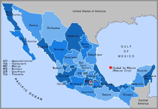
Baja California is a state in Mexico, the northwesternmost of the country's 32 federal entities. It became a state in 1952, prior to which it was known as the North Territory of Baja California. The state comprises the northern half of the Baja California peninsula, plus Guadalupe Island, and is bordered by the Pacific Ocean, Sonora, the Gulf of California, Baja California Sur, and the United States.
- Capital
- Mexicali
- Statehood
- 1952
Lore & Background
Europeans reached the area in 1539 with Francisco de Ulloa, followed by Hernando de Alarcón and Juan Rodríguez Cabrillo. Jesuit missions were established in the 18th century, and after the Jesuits' expulsion, Franciscans and then Dominicans administered the region. In 1804, the Spanish crown divided California into Alta and Baja California. After Mexican independence, the Mexican-American War resulted in the U.S. gaining Alta California, while Baja California remained Mexican. In 1952, the North Territory became the state of Baja California.
Reader's Guide
Baja California is significant as the northwesternmost state of Mexico, bridging the border with the United States and containing major cities like Tijuana and Mexicali. Its geography ranges from Mediterranean-like valleys and pine forests in the mountains to the Sonoran Desert in the east. The Valle de Guadalupe is Mexico's premier wine-producing area. Its population is concentrated in the north, with over 75% living in Mexicali, Ensenada, or Tijuana. The state also includes Guadalupe Island, the westernmost point of Mexico.
Did You Know?
- The Baja California peninsula extends from Mexicali in the north to Cabo San Lucas in the south, with a length of 1,247 km.
- The peninsula's width ranges from 40 km at its narrowest to 320 km at its widest point.
- The total area of the Baja California peninsula is 143,390 km².
- In 1539, explorer Francisco de Ulloa proved that Baja California was a peninsula rather than an island.
- The first printed map showing California as an island was published by Henry Briggs in 1622.
Frequently Asked Questions
Who is Baja California?
Baja California is the northwesternmost of Mexico's 32 federal entities, covering the northern half of the Baja California peninsula plus Guadalupe Island. It sits at the country's western edge, flanked by the Pacific Ocean, the Gulf of California, Sonora, Baja California Sur, and the United States.
What are Baja California's powers and role?
As a full state, Baja California operates with its own capital in Mexicali and a 2020 population of roughly 3.77 million people. It contributes to the national economy through cross-border trade, agriculture, and a well-known wine region.
How does Baja California's story end?
The territory's arc from the North Territory of Baja California to full statehood wrapped up in 1952, when it was admitted as a state. It has held that status continuously ever since, spanning about 70,113 square kilometers.
Why is Baja California important?
Its position as the northernmost stretch of the Baja peninsula makes it a pivotal border zone between Mexico and the U.S. The state is also celebrated for its varied landscapes and for being a leading Mexican wine-producing region.
What is Baja California's highest point and largest city?
Picacho del Diablo tops out as the state's highest elevation across its desert-to-coast terrain. Tijuana is the most populous urban center, while Mexicali serves as the official capital.
More in Mexican States 1-19
Related in Mexican States
Links follow this subject's own source article.
Spotted an error? Know more?
This is a living reference — every entry is fact-audited, and reader corrections feed straight into our audit queue. Suggest an edit · See this site's audit record