Querétaro
A small Mexican state with vast geographic and ecological diversity.

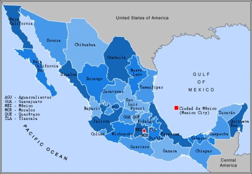
Querétaro, officially the Free and Sovereign State of Querétaro, is one of the 32 federal entities of Mexico. It is located in north-central Mexico, in a region known as Bajío, and is bordered by the states of San Luis Potosí, Guanajuato, Hidalgo, México, and Michoacán. Its capital city is Santiago de Querétaro, which dominates the state culturally, economically, and educationally. The state is one of the smallest in Mexico but is geographically heterogeneous, with ecosystems ranging from deserts to tropical rainforest, particularly in the Sierra Gorda.
- Capital
- Santiago de Querétaro
- Number of municipalities
- 18
- Region
- Bajío, north-central Mexico
- Geographic zones
- Mesa del Centro, Sierra Madre Oriental, Trans-Mexican Volcanic Belt
- Major river basins
- Lerma/Santiago and Pánuco
- Average temperature
- 18 °C (64 °F)
Lore & Background
Querétaro is divided into 18 municipalities, including Amealco de Bonfil, Arroyo Seco, Cadereyta de Montes, Colón, Corregidora, El Marqués, Ezequiel Montes, Huimilpan, Jalpan de Serra, Landa de Matamoros, Pedro Escobedo, Peñamiller, Pinal de Amoles, Querétaro, San Joaquín, San Juan del Río, Tequisquiapan, and Tolimán. The state's territory was on the northern edge of Mesoamerica, with the Purépecha Empire and Aztec Empire influencing the extreme south but neither dominating it. By the time the Spanish arrived, the area was independent from imperial powers, inhabited by small agricultural villages and seminomadic peoples. Spanish conquest focused on the establishment of Santiago de Querétaro.
Reader's Guide
Querétaro's significance lies in its remarkable geographic and ecological diversity within a small area. The state contains five distinct geographical regions: the Sierra Gorda, El Semidesierto Queretano, Los Valles Centrales, El Bajío Queretano, and La Sierra Queretana. The state's ecosystems include 18 different classifications, from deciduous rainforest to arid scrub brush. Three major Mexican geographic zones—the Mesa del Centro, Sierra Madre Oriental, and Trans-Mexican Volcanic Belt—cover parts of the state. The Cerro del Cimatario has been declared a national park and biosphere reserve.
Did You Know?
- Querétaro is one of the smallest states in Mexico but has ecosystems ranging from deserts to tropical rainforest.
Economic Renaissance and the Industrial Engine of the Bajío
Querétaro's transformation into one of Mexico's most dynamic economic hubs began in earnest during the mid-1990s, and the results have been remarkable. The city has earned the distinction of being the fastest-growing in the entire country, fueled by a diversified industrial base that spans information technology and data centers, logistics, aircraft manufacturing and maintenance, call centers, automotive and machinery production, as well as chemicals and food processing. Major international corporations in aerospace, electronics, automotive, chemical, food, and financial sectors have chosen Querétaro as the location for their national headquarters. Beyond heavy industry, the region has cultivated a thriving viticulture sector, now producing the second-largest volume of wine in Mexico behind Baja California, and is home to the renowned Spanish producer Freixenet. This sustained growth has drawn significant internal migration from other parts of the country, reinforcing the city's status as a vigorous service and business center undergoing continuous social and economic revitalization.
Pre-Hispanic Roots and the Name That Captivated a Nation
Long before European contact, the Querétaro basin was a living landscape of Mesoamerican civilization. Archaeological evidence points to settlement around AD 200 by groups moving northward, with clear Teotihuacan influences visible at local sites. During the Classic Period, two population centers—Toluquilla and Las Ranas—flourished, while the hill now called El Cerrito served as a ceremonial center before its mysterious abandonment. By the later pre-Hispanic era, the Otomi had established themselves as sedentary urban dwellers with sophisticated political structures, organized under the dominion of Xilotepeque and ultimately subject to the Aztec Empire. The Aztecs administered the region directly under Ahuizotl in the late 15th century, viewing it as a strategic bulwark against Chichimeca territories to the north.
The Founding and the Legend of Santiago
The Spanish and their Nahuan allies were battling local Otomi and Chichimeca insurgents at a hill called Ynlotepeque—now Sangremal—regarded as sacred in pre-Hispanic times. According to chronicles such as Friar Isidro Félix de Espinoza's, the Chichimeca were on the verge of victory when a total solar eclipse struck. The event reportedly terrified the Chichimeca, and the Spanish claimed to have seen Saint James riding a white horse bearing a rose-colored cross. The Chichimeca surrendered, and the city took its Santiago name from this patron saint. A stone cross was erected on the hill, later joined by a church and monastery. Yet Spanish dominion was never secured by a single battle; Bocanegra's earliest attempts to establish a city had been repelled, forcing him south to found Huimilpan and Acámbaro. Conín's cooperation ultimately helped end the conflict, and he was appointed governor of the area, though early colonial years remained marked by skirmishes over encomienda establishment.
Living Heritage and the UNESCO Crown
The municipality is divided into seven boroughs, and the city carries an Aztec glyph that marked it as a tributary province within the empire. What makes Querétaro's heritage particularly distinctive is its continuity: the Otomi and Chichimeca peoples who inhabited the region during the pre-Hispanic and colonial periods remain present in the area today, their ancestral territories and cultural presence woven into the modern fabric of the city. The Otomi, who organized themselves into familial clan-like groups with defined territories and lived in stone, wood, or adobe dwellings, were sedentary farmers who engaged in warfare but never elevated it to the cultural centrality the Aztecs did.
Frequently Asked Questions
What is Querétaro and where is it located?
Querétaro is one of Mexico's 32 federal states, tucked into the Bajío region of north-central Mexico. It shares borders with five neighbors: San Luis Potosí, Guanajuato, Hidalgo, México, and Michoacán.
What is the capital city of Querétaro?
Santiago de Querétaro is the state capital and functions as its cultural, economic, and educational center. It anchors the 18 municipalities that make up the state.
How geographically diverse is Querétaro?
For one of Mexico's smaller states, Querétaro packs a surprising range of ecosystems, stretching from dry desert terrain to tropical rainforest in the Sierra Gorda. Its landscape spans the Mesa del Centro, the Sierra Madre Oriental, and the Trans-Mexican Volcanic Belt.
What is the average climate like in Querétaro?
The state's mean temperature sits around 18 °C (64 °F), but that single number hides a lot of local variation. Microclimates shift noticeably between the central plateau and the mountainous eastern zones.
Which major river basins flow through Querétaro?
Two principal drainage systems shape the state's waterways: the Lerma/Santiago basin and the Pánuco basin. These rivers underpin agriculture and ecology across the region.
More in Mexican States 1-19
Spotted an error? Know more?
This is a living reference — every entry is fact-audited, and reader corrections feed straight into our audit queue. Suggest an edit · See this site's audit record